1/9


Trainsity Kuala Lumpur LRT KTM
1K+下载次数
11.5MB大小
2.10.0(15-01-2025)最新版本
详情评价版本信息
1/9
Trainsity Kuala Lumpur LRT KTM介绍
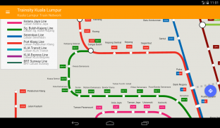
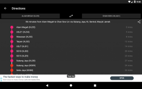
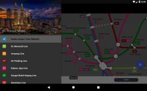
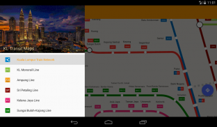
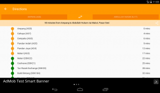
使用KTM Komuter线,RapidKL线和KLIA Express Rail Link线(包括BRT Sunway线)的高分辨率矢量地图,在吉隆坡市内寻路。这些地图的文件占用空间较小,但具有多个缩放级别,可以在不连接到Internet的情况下脱机工作。用户可以单击火车站标签以打开Google地图或街景视图,在这里可以使用Google应用程序的所有功能来可视化周围区域和/或执行路线导航。还有一个离线功能,可以计算出从一个站点到另一个站点的最佳旅行方式,其中包含方向细分和时间安排(可能与实际旅行时间有所不同)。
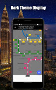
*现在具有黑暗模式
Trainsity Kuala Lumpur LRT KTM - 版本2.10.0
(15-01-2025)新特性Replace deprecated database library.New select favorite stations activity.
Trainsity Kuala Lumpur LRT KTM - APK信息
APK版本: 2.10.0程序包: com.dom925.trainsity.kualalumpur名称: Trainsity Kuala Lumpur LRT KTM大小: 11.5 MB下载次数: 1版本: 2.10.0发布日期: 2025-02-12 14:03:43最小屏幕: SMALL支持的CPU:
程序包ID: com.dom925.trainsity.kualalumpurSHA1签名: E5:9D:19:FD:8D:A4:3A:AF:CD:14:FF:7A:C8:C2:21:93:15:E5:49:67开发商 (CN): Dominic Chin组织 (O): 本地 (L): 国家/地区 (C): SG州/市 (ST): 程序包ID: com.dom925.trainsity.kualalumpurSHA1签名: E5:9D:19:FD:8D:A4:3A:AF:CD:14:FF:7A:C8:C2:21:93:15:E5:49:67开发商 (CN): Dominic Chin组织 (O): 本地 (L): 国家/地区 (C): SG州/市 (ST):
Trainsity Kuala Lumpur LRT KTM的最新版本
2.10.0
15/1/20251 下载次数11 MB 大小
其他版本
2.9.310
6/8/20241 下载次数8 MB 大小
2.7.200
22/11/20231 下载次数4 MB 大小
2.5.100
25/3/20231 下载次数4 MB 大小
2.2.95
14/8/20201 下载次数3 MB 大小
1.3.3
3/7/20161 下载次数3.5 MB 大小


同类应用


English


